
Publication is originally from Fast Time in Palestine
Before I start posting excerpts from my book, I wanted to put together a few maps that will make them (and the conflict in general) much more intelligible.
First, here’s a general map of the Middle East, with Israel circled in blue:

 |
| a schematic map of Israel and the occupied Palestinian territories — the West Bank and Gaza Strip |


Above is a close-up of the West Bank.
 |
| the central spine of the West Bank are the Palestinian cities of Jenin, Nablus, Ramallah, Jerusalem, Bethlehem, and Hebron. To the northwest are Tulkarem and Qalqilia, and in the desert north of the Dead Sea, there’s Jericho, where it’s always summer. |
This map is a little tricky, but let me explain, because it’s very important. Under the Oslo Accords of 1993, the Palestinian territories were divided into three areas: Area A (17%) falls under the nominal security and civil control of the Palestinian Authority (PA), although the Israeli army reserves the right to enter at will. Area B (24%) falls under Israeli security control, with the PA responsible for some civil affairs. Area C (59%) falls under total Israeli civil and military control.
Area C contains virtually all Israeli settlements and settler roads, large buffer zones around them, most of the Jordan River valley, and all of the Dead Sea coast. Areas A and B are divided into many ‘islands’ separated from one another by Israeli-controlled Area C. According to the Oslo Accords of 1993, Area C was supposed to transition to Palestinian control within five years. Instead, the Israeli government continues to fill Area C with settlements and to restrict Palestinian access to it.
So this is a detailed map of the settlements and of Areas A, B, and C. Dark red patches are Palestinian cities and villages, orange and tan patches are Areas A and B, and the rest of the territory is Area C. Dark blue patches are Israeli settlements while teal and pale blue areas are settlement municipal boundaries and jurisdictional areas. (Hebron, with its green and brown areas, is its own special case and will be discussed in Chapter 10.) Source: B’Tselem(The Israeli Information Center for Human Rights in the Occupied Territories).
The settlements are usually built on hilltops (so they can keep an eye on everything in their area) near fertile land, aquifers, Palestinian population centers, and/or sites that are holy to all three major monotheistic religions. Control of water is particularly important, as the groundwater is being taken out of the Holy Land faster than it’s being replaced. Now Israel has control over virtually all of it — some of the largest settlements built deepest into the West Bank are built over major aquifers — and they often take water out of the West Bank and sell it back to the Palestinians at low volumes and inflated prices. Palestinians find it nearly impossible to get a permit from the Israelis to build much-needed wells on their own land.
Thus it is a common sight to see Palestinians rationing drinking water in the summer while settlers top off their swimming pools and water their lawns. The settlement enterprise is, among other things, an attempt to make Israeli control over West Bank water permanent.
Amnesty International recently published a report about Israel’s denial of basic water rights to Palestinians. Read the BBC’s summary of it here.
 |
| This is a picture of the Wall Israel is building. The black lines are sections of the Wall already finished as of February 2007 while the red lines are sections that are approved and/or under construction. |
This is a picture of the Wall Israel is building. The black lines are sections of the Wall already finished as of February 2007 while the red lines are sections that are approved and/or under construction.
Whenever the Wall’s route deviates from the Green Line (the border between the West Bank and Israel), it is being built on occupied Palestinian land and is illegal according to international law. Its illegality was confirmed by the International Court of Justice in 2004. All the blue dots and splotches are settlements, and the white areas are settlement areas behind the Wall that are totally controlled by Israel. Most of these areas are Palestinian land, much of it Palestinian private property that was illegally expropriated for the settlements or for Israeli-only roads.
This map does not include the more than 600 internal checkpoints and roadblocks that further break up and isolate each part of the West Bank from the other — sometimes going so far as to make it impossible or illegal for people to leave their villages by car at all, forcing them to walk to a main road and try to find a taxi — but this gives you a small idea of what Palestinians go through.

Here’s a close-up of the Wall in the Qalqilia and Jayyous area. Jayyous is the village — the grey blotch — just under the yellow box that says “Nofei Zufin.” I have spent many happy days there. As you can perhaps make out, the Wall in this area isolates or destroys most of Jayyous’ land. All of Jayyous’ seven water wells were isolated by the Wall. A settlement called Zufin has already been built illegally by Israel on Jayyous’ land, and another settlement called Nofei Zufin is in the process of being built. Farmers find it increasingly impossible to get permission from Israel to work their land that falls on the other side of the Wall while settlements (the blue blotches and their light blue areas of planned expansion) continue to expand all over the West Bank. As you can see, the entire city of Qalqilia is surrounded by the Wall, which in this area is a 25-foot-tall concrete structure punctuated by sniper towers.
According to the UN Relief and Works Agency, “Jayyous and neighboring Falamyeh were well known for their intensively-irrigated agriculture which produced vegetables and citrus fruit, together with figs, apricots, loquats, mangoes and almonds. There are also thousands of olive trees… Four thousand trees were uprooted for the Barrier and 125 acres of land leveled. The Barrier isolates some 9,000 dunums [2,250 acres], representing between 75 to 90 percent of its fertile land. Also isolated are 120 greenhouses belonging to Jayyous and Falamyeh and six water wells. Jayyous now shares water with Azzun from a well located between the two villages, which covers less than 50 percent of its needs, with water rationed to two hours per day in summer.”

Above is a picture of the Wall around Qalqilia, from the inside. Note the sniper tower just above and to the right of the men in the cart. I should hasten to add, though it should be obvious, that Israel’s justification for all of this is ‘security.’ But an article in Israel’s Haaretz newspaper stated on January 2, 2006, “The security fence is no longer mentioned as the major factor in preventing suicide bombings, mainly because the terrorists have found ways to bypass it. The fence does make it harder for them, but the flawed inspection procedures at its checkpoints, the gaps and uncompleted sections enable suicide bombers to enter Israel… The main reason for the sharp decline is the truce in the territories, the security service said… The fact that Hamas, in general, stopped engaging in terror activities changed the picture… Its focus on the political arena and the preparations for the Palestinian parliamentary elections have limited its active involvement in terror to a large extent.”
This was before the world refused to recognize the results of the democratic Palestinian elections in January 2006, with disastrous results. But the important point is, even the Israeli security services know in their hearts that there is no military solution to this conflict. You can’t ghettoize, arrest, shoot, and bomb Palestinians into submission forever. Any reasonable solution to this conflict has to be political.
Aside from this, if anyone looks at these maps and doesn’t believe that at least one purpose of the Wall is to grab as much Palestinian land with as few Palestinians on it as possible, please leave a comment and explain. I would be very interested to hear.

Above is a map of the Wall in East Jerusalem. This picture represents more pain and heartache than I can summarize in a paragraph, but I’ll explain as well as I can. The grey area is Israel (including Israeli West Jerusalem) while the white area is the occupied West Bank. The tan areas are Palestinian cities and villages (Ramallah in the north, Palestinian East Jerusalem in the middle, Bethlehem in the south). The purple areas are Israeli settlements, all built illegally on Palestinian land. Many of these are being expanded and new ones are being built. The red line is the planned route of the Wall.
Notice how the Wall weaves around to isolate as many Palestinian areas as possible from East Jerusalem while seizing as many settlements and as much land as possible. Bethlehem has been particularly devastated. Not only does the Wall surround it and isolate most its land, turning it into a ghetto, the Wall and settlements break the ancient link with its sister holy city Jerusalem. Notice also how many Palestinian communities are separated or cut off from each other — Shu’fat and Shu’fat Refugee Camp, Beit Hanina and Beit Hanina al Balad, East Jerusalem and Abu Dis, and on and on.

Above is the checkpoint near Qalandia village between Ramallah and Jerusalem. Most of my Palestinian friends in Ramallah can’t get permits from the Israeli army to cross this checkpoint and visit Jerusalem, even if they were born there or went to high school there. Foreigners can breeze straight through. I never get used to this.
Below are three pictures of the Wall in East Jerusalem.


A silent commentary on the historic crime of separating the cities of Bethlehem and Jerusalem:

Tom Toles put it well. (Note the small text in the bottom right hand):

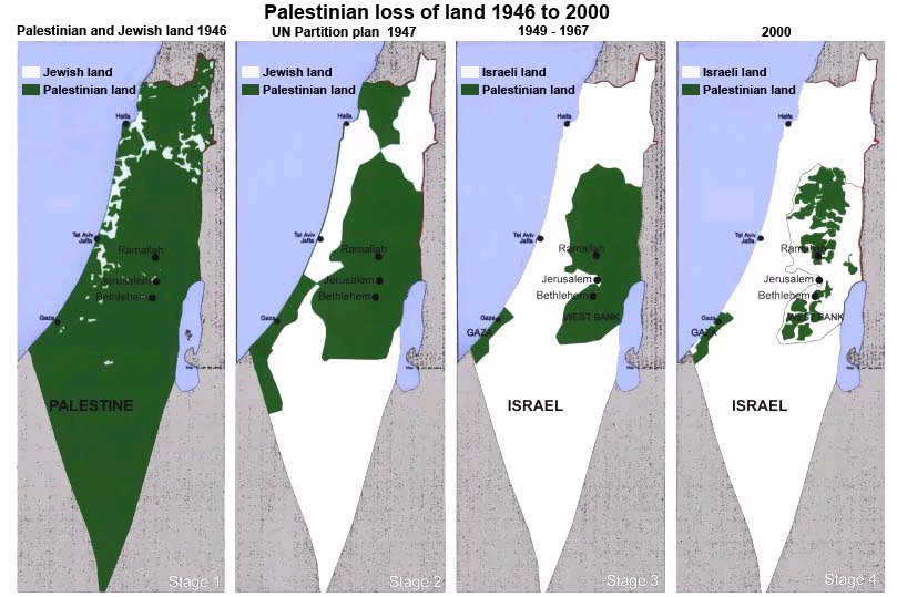
The map below shows the evolution of sovereignty over historic Palestine from 1946 to the present. The first panel shows approximately how much land was owned by Jewish residents in 1946. The second shows the UN partition plan, which proposed giving 55% of the land to Jewish sovereignty even though Jews owned about 7% of the land. The Arab world rejected this, but they were overpowered by well-armed and organized Zionist militias funded and aided by Europe. In 1948, the state of Israel was declared on the white area in the third panel.
In 1967, Israel also conquered the West Bank and Gaza, and the fourth panel shows Areas A and B as staked out under the Oslo Accords — the less than half of the West Bank and Gaza that falls under even limited Palestinian control. Many Israeli leaders in high government office claim much of Area C as Israeli territory and would prefer to force the Palestinians to live in cantons or ghettos largely confined to Areas A and B without meaningful sovereignty, and label this a “two-state solution.” The Palestinians will never allow it to happen, and neither should people of conscience anywhere in the world.
If you’re wondering what any of this has to do with you as an American (if you’re an American), Israel is the largest recipient of US foreign aid in the world. We give them over $3 billion a year — that’s $10 million every single day — of our tax dollars. This is what they do with it. The US government has also vetoed dozens of UN resolutions condemning Israel’s violations of international law. Americans more than anyone else have the power to put pressure on Israel to change its policies.
Unfortunately, the Israel lobby is one of the most powerful in Washington while Palestinians have virtually no presence on Capitol Hill. Very few Senators and Representatives are willing to pay the political price of crossing the Israel lobby based on principle alone. Therefore it’s up to us to learn more about this situation and put pressure on our representatives to end America’s support of Israel’s illegal policies.
For more thorough historical and political context as well as human stories about life behind the Wall (including many wonderful and hilarious ones — despite it all, Palestinians are some of the most welcoming people in the world with a deep love of their land and appreciation for a good time), stay tuned for my book, forthcoming in 2010.